This page summarises the history of our Wendover Canal, and the reservoir and pumps that were built around it. At the bottom of the page are a number of links to more detailed articles.
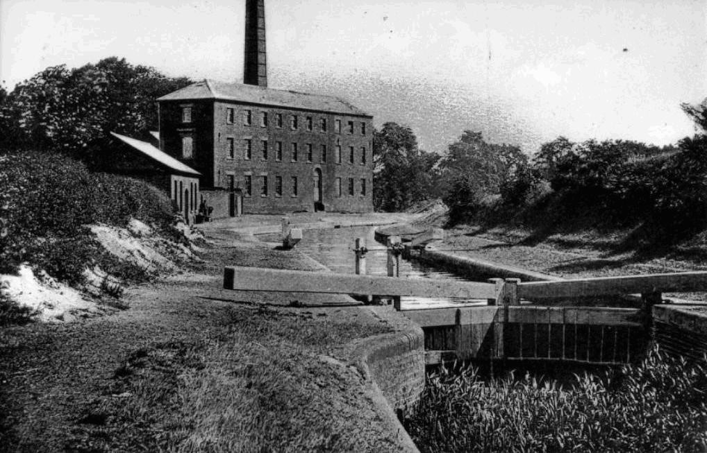
The photo right shows Tringford pumping station and stop-lock in 1910. However the pumping station was considerably reduced in height a few years after this, when the steam beam engines within it were scrapped. The stop-lock was never a lock in the conventional sense because there was no change in level. It was just somewhere to close off the canal if the leaks became too much. Not long after it was built, the canal was closed anyway, so it served little purpose. For more details, see the links at the foot of this page, also read on…
Grand Union Canal
The Grand Union (formerly the Grand Junction) canal was designed to be part of a system of canals linking with each other. It forms a main artery to link the prime routes from London and the south to Birmingham and the Potteries.
The main line of the Grand Union Canal starts at the River Thames at Brentford westward to Cowley Junction (access to the Slough Arm). It then runs north and north west to the Midlands. Commercial traffic on the Grand Junction Canal increased very rapidly – the canal was the “M1” of its day.
With a wide variety of landscapes and numerous towns and historic canalside halts, the GU offers various options. There are many “arms” (branch canals) from junctions. These include Bulls Bridge (Paddington Arm leading to the very heart of London), Marsworth (Aylesbury Arm), Gayton (Northampton Arm), Norton (Leicester Section), Braunston (Oxford Canal), Napton (Oxford Canal), and Kingswood (Stratford on Avon Canal). At Bordesley Junction in Birmingham, the Grand Union enters the Digbeth Branch and the Birmingham & Fazeley canal.
Tring Summit
The Grand Union Canal ascends some 380 feet from its junction with the River Thames. After a climb of 56 locks in over 36 miles, it reaches the 2.5 mile long Tring Summit. Here the descent northwards commences, towards what we now called Milton Keynes. It then rises again to another summit at Braunston.
The Tring Summit was completed in 1797, in advance of the main line to north and south. As this stretch of water was to supply the needs of the canal on both sides of the summit it became imperative to find sufficient water. The first Act of Parliament for the canal stated the need for a feeder from the north side of the Chiltern Hills behind Wendover to the summit level. The Wendover Canal, which was originally known as the Wendover Arm, became the first of several feeders to the summit level.
Work started on the construction of the Wendover Canal in the summer of 1793. It follows the 390 foot contour to join the Tring summit of the Grand Junction Canal at Bulbourne. After construction of the Arm had started, it was soon realised that little extra expense would be incurred in making the feeder navigable. Authority to carry out this work, costing £13,000, was obtained in 1794. The Wendover Canal was primarily built to supply water for the locks each end of the Tring Summit. But it was also served by many wharves along its length sending local produce to the London markets and also receiving coal, timber and manure for use on the land. Four reservoirs were built in the Tring area to store water for canal use.
The Long Decline
But the commercial life of the Wendover Canal was short. By 1802 there was a considerable loss of water through the banks and the canal was closed for repairs to be carried out. By 1841, 20 locks of water were being lost per day through leakage. Extensive re-puddling (lining with clay) over a length of four and a half miles was carried out. To no avail, however, as by 1855 some 25 locks of water were escaping. Further repairs by 1858 saw the lining of the leaking parts of the canal with a layer of coal tar two and a half inches thick. In spite of this, by 1870 the loss was 30 locks of water per day. Repair work continued in 1895-96. In 1897 the leakage was so large that the Arm was actually taking water from the main line.
Trade was lost to the nearby Aylesbury Canal (Arm) which did not suffer from the same problems. This of course meant that the Wendover Canal became less commercially viable. Stop-planks were put in at Little Tring with the result that, although the Wendover Canal was severed, the level of water in the summit pound immediately improved. A stop-lock (which can still be seen next to Tringford Pumping Station) was constructed at Little Tring. This allowed the Arm to be used for traffic should the water situation improve.
Part Closure
In 1904 the Wendover Canal was blocked at the stop lock near Little Tring. The next 1¼ miles was dewatered, and the water level lowered on the remaining 3¾ miles. This was despite massive protests from local people, the Royal Commission for Canals and Waterways, and the County Councils of Herts. and Bucks. From 1918-28, a short section was filled with domestic rubbish by Tring Urban District Council.
Early in the 20th century, so that some of the water could still be carried, an 18 inch pipe was laid in the canal bed for 1¾ miles near Tring. (100 years later the leaks are worse and the pipe is in urgent need of replacement.)
Bridges have been lowered, culverted or demolished, despite the strenuous efforts of many organisations. Finally at a meeting in October 1985, instigated by the Grand Union Canal Society, a steering committee was formed. This became the Wendover Arm Trust.
The Wendover Canal Trust is fully restoring and relining the canal to stop the leaks. British Waterways gave the Trust the £200,000 that they said they would have spent on replacing the pipeline. Wendover Canal Trust has to find the rest. To read about our restoration work, please click here.
Find out more at these links
For a more detailed history, one source is Tring Local History Museum here .
To download a summary of the building of the Wendover Canal’s pumps and reservoirs click on the link below:
Download a very detailed description of the pumps and reservoirs. (This was written by our former Vice President the late Barry Martin, from which the above was summarised)
There is a very detailed article on Wendover Canal/ Grand Union summit water supplies and pumping up to 1969. It can be found in two parts in the online journal of the Railway and Canal Historical Society (RCHS) at this link . Scroll down to Apr1969 for Part 1 of the article, and Jul1969 for Part 2.
RCHS have also published a history of the development and measurement of water flows from Wendover. It can be found at this link.
Download a modern diagram of the water flows: