Introduction
The Heritage of the Wendover Canal has been created over more than 230 years. It stretches for 11km/ 6.75 miles among the Chiltern Hills, and was historically known as the Wendover Arm. The Wendover Canal links the picturesque village of Wendover, Bucks to the Grand Union Canal at Bulbourne, Herts. It is level from end to end, at 390 feet/119 metres above sea-level, the same height as the top of St Paul’s Cathedral. Our continuing restoration of the Wendover Canal offers a great opportunity to open up and celebrate the local Heritage.
The Heritage of the Wendover Canal
The Wendover Canal excels in the heritage of the built environment, allied to the original use of the canal. Canal building led to a set of unique and diverse heritage features, all of which are worthy of protection. The Canal helps tell the story of Britain’s industrial past, but it is not a museum. It is an asset which we can all enjoy and employ today. Its scale and accessibility remain important for tourism, physical and mental health, and our national sense of identity.
Below are the main Heritage features of the Wendover Canal, starting from Wendover and proceeding along the canal toward Bulbourne. We have not given postcodes, because many sites are away from locations which postcodes can take you to. Instead, we have used “What Three Words” (W3W). W3W allocates a unique three-word combination to any chosen location, within a 3x3metre (10 feet) square. Search ‘w3w’ on the Internet, and enter the exact three given words in the format xxx.yyy.zzz to see the location.
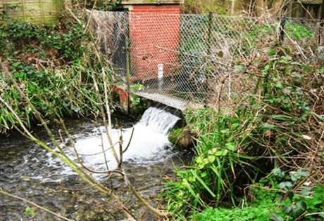
Water Flow Gauge
Where: At the ultimate terminus of the canal in Wendover, where the water flows from Heron Brook into the canal.
Location: A few yards from Wharf Road, down onto the towing path. Signposted from Wharf Road, Wendover.
W3W Location: ///shakes.bunkers.convinced
What is it? A water flow gauge, measuring the flow from Wendover Springs into the Wendover Canal via the Heron Brook. The gauging station is thought to be the earliest extant stream flow monitoring site in the UK. The continuous records provide unique insights into rainfall and weather patterns, from the Victorian era in 1841, to the present day. We can use these results to quantify and inform the effects of climate change on water resources. The meter is still in current use.
Further reading: For external websites, explore these links:
www.nrfa.ceh.ac.uk – then use search term ‘wendover’
www.geograph.org.uk – then use search term ‘wendover flow gauge’
The Wides
Where: Along the Canal towards Halton.
Location: A few hundred yards along the towing path from Wendover in the direction of Halton, away from housing or other buildings.
W3W Location: ///adhesive.slugs.messy
What is it? A short length of the Canal where the width is much greater. This gives more scope for reed and water plant growth, and provides habitat for aquatic birds. It was the location of the mill pond from a former water mill. It is also the location of local springs feeding the canal.
Further reading: For external websites, explore these links:
www.canalplan.uk/place/z23k
www.geograph.org.uk – then use search term ‘The Wides’
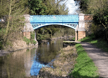
Rothschild Bridge
Where: A few yards NE of Halton Bridge, Halton Village, Aylesbury, Bucks.
Location: Bridge 8A, 1¾ miles/ almost 3km from Wendover.
W3W Location: ///flip.sapping.stands
What is it? A Grade II Listed accommodation (pedestrian) bridge across the Canal, built by Baron Alfred de Rothschild in 1880. Notable for its ornate blue ironwork including the Rothschild Monogram picked out in gold paint. This was to complement the elaborate Palladian-style of Halton House (which replaced the original Manor House, destroyed by fire, and demolished in 1879).
The bridge was renovated by the RAF in 1992 in association with Christopher Wallis, son of Barnes Wallis designer of the WWII Bouncing Bomb and the Lancaster Bomber.
Further reading: For external websites, explore these links:
www.geograph.org.uk – then use search term ‘Rothschild Bridge’
www.canalplan.uk/place/tvm4
Whitehouses
Where: Approximately midway between Drayton Beauchamp, Bucks and Little Tring, Herts
Location: On off-side bank of the Canal. Accessible by foot, cycle.
W3W Location: ///dice.defaults.boots
What is it? Site of ‘White Houses’ dwellings, originally for canal and steam driven water pump maintenance workers. Long ago in 1802, a Newcomen-type engine pumped water from Wilstone reservoir, the first of four reservoirs to be built. The double fronted house was converted after 1938 to a refuge for German and Austrian Refugees from Nazi Germany. It was also used during the London Blitz as a respite from the bombing. The site was later levelled because it was not a “home fit for heroes”.
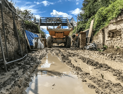
Today: We have conserved the cellars, canal walls and water portals, including re-siting and replacing water sluices down to Wilstone Reservoir. Our volunteers have undertaken much landscaping and planting to provide a ‘pocket park’ for general community benefit, including the planting of 500+ tree saplings and 1000 daffodil bulbs.
Further reading: For external websites, explore these links:
kescrgonline.co.uk/whitehouses
www.livingmags.info/whitehouses-pocket-park-on-the-wendover-canal/
Bridge 4
Within sight of Whitehouses, this is the site of a former swing bridge which connected a track between the Lower Icknield Way and Wilstone Village. Our volunteers replaced it with a wooden foot-bridge to maintain the designated footpath. We are now conserving the swing bridge abutments and restoring them with heritage bricks.
Little Tring Bridge
Where: Little Tring, Dacorum, Herts
Location: The intersection of the Wendover Canal and Little Tring Road.
W3W Location: ///arriving.reefs.option
What is it? We funded this new road bridge, built skew over the canal in 2003 and finished in traditional hand-made bricks with lime mortar. We built a display of bricks, so that people could choose which brick finish we should use. This is still in place, alongside the towpath a short distance in the Wendover direction away from the bridge.
Herts County Council demolished the original hump-back bridge in 1973, after the introduction of larger and heavier trucks was allowed. We included replica rubbing strakes showing the grooves cut into the iron by repeated friction from working boaters’ ropes.
Further reading: Click here for more about Little Tring Bridge on this website.
For external websites, explore these links:
en.wikipedia.org/wiki/Wendover_Arm_Canal
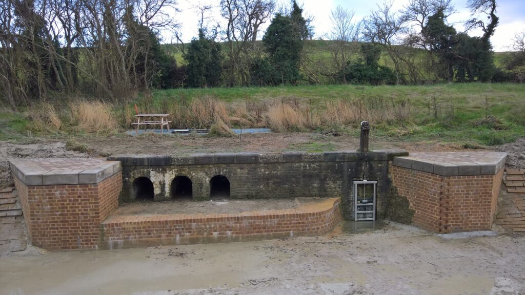
Tringford “Stop Lock”
Where: Little Tring, Dacorum, Herts
Location: Between Little Tring Bridge and Tringford Pumping Station nearby.
W3W Location: ///skims.beginning.went
What is it? The canal company constructed the stop-lock after stop planks had been installed in 1897. The canal was leaking so badly that instead of supplying water from Wendover, it was draining water from the summit section of the Grand Union Canal. With the lock in place, boats could still pass through when the levels on either side were not necessarily equal.
Although referred to as a “stop lock”, it was a working lock with an upper pair and a lower pair of gates. The gates were kept open when there was enough water. However at times of low water, both pairs of gates were shut, protecting the water level along the Tring summit from loss of water along the Wendover Canal. Boats which were desperate to deliver their load, could still lock down and try and get along the leaky Wendover Canal. They accepted the risk of getting grounded and stuck, rather than lose money by failing to deliver.
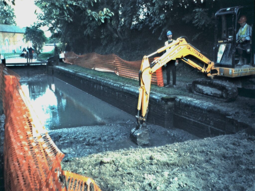
Today: The top gates are still in place, the lock structure is in good condition, but the bottom gates and paddles are missing.
The lock was the start point of our restoration, and the picture shows us dredging the lock with Tringford pumping station in the background.
Tringford Pumping Station
Where: Little Tring, Dacorum, Herts
Location: Adjacent to the intersection of the Wendover Canal and Little Tring Road.
W3W Location: ///mallets.specifies.rooting
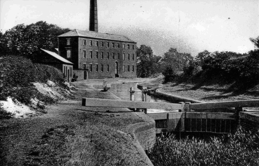
What is it? Dating from 1815, this Grade II listed building houses pumps to raise water up to the canal from wells connected to the 4 reservoirs (Startops, Tringford, Marsworth and Wilstone). This is the only pumping station remaining on the Wendover Canal. The building (as shown here in 1910) originally housed a long-gone Boulton and Watt Steam Engine, capacity 80 locks-full per day. Electric pumps are in use today, installed in 1927 within the original wells, at which time the building was sadly lowered by two-thirds.
Today: When we finish restoring the Wendover Canal between Drayton Beauchamp and Little Tring, the water from Wendover will be able to flow by gravity all the way as it was originally designed to do. The need for pumping at Tringford will be reduced considerably, lowering the operating cost and the environmental impact.
Further reading: Click here for more on this website.
For external websites, explore these links:
historicengland.org.uk/listing/the-list/list-entry/1067754
Flour Mill at Gamnel Bridge
Where: New Mills, Tring, Dacorum, Herts
Location: At the intersection of the Wendover Canal and Tringford Road.
W3W Location: ///status.umbrellas.breezy
What is it? Large imposing canal-side mill, where Tring’s oldest continuous business of Milling Flour has been conducted since 1875, initially by Mead. Before this mill was built, there was a smaller milling business initially run by William Grover, from 1810.
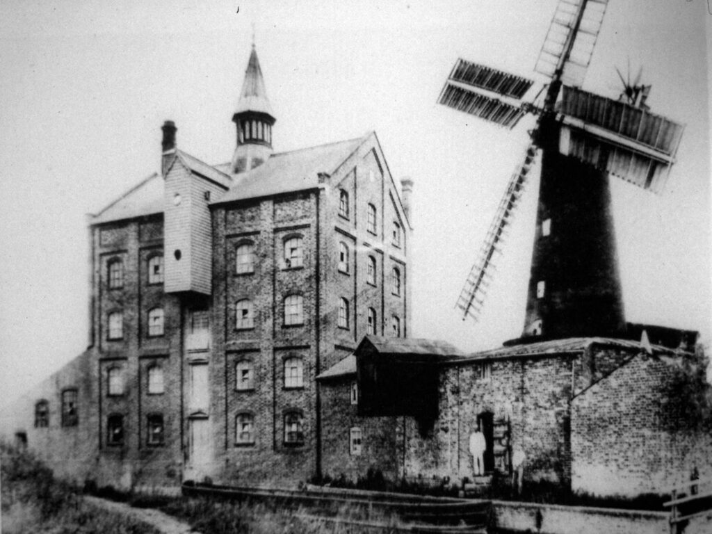
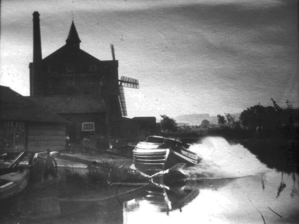
Mead milled flour for local consumption, initailly using the six-storey tower-type windmill also seen opposite. The canal brought wheat for milling to Gamnel Wharf (New Mill) until the end of WWII.
The windmill was demolished on May 4th 1911, with milling continuing using a steam-driven roller mill in the large brick building. They eventually replaced this by more productive milling methods, increasing the hourly output from an original half-ton to over 12 tons. Heygates Ltd acquired the mill in 1944, and operates it as a flour and grain mill to this day.
Further reading: Explore these links:
www.heygates.co.uk
www.tringlocalhistory.org.uk
Bushells Boatyard (site of)
Where: Little Tring, Dacorum, Herts
Location: Adjacent to the intersection of the Wendover Canal and Tringford Road.
W3W Location: ///templates.ghost.tweeted
What is it? Site of former boatyard, now incorporated into the Flour Mill property. In 1850 John Bushell began repairing some of the boats operating to Mead’s flour mill. His son Joseph developed this into a separate business in 1875. In 1912 Joseph’s sons began trading as Bushell Brothers.
Boats were of all-wooden construction, and boat repair and building took place in the open air. Some years later, an open-sided barn-type shelter was built. Later work undertaken by the boatyard included road vehicle bodywork and construction. The last known all-wooden narrowboat ‘Roger’ built by Bushells is still in existence and is owned and operated by Rickmansworth Waterways Trust. The boatyard business ceased with the retirement of the Bushell brothers in 1952.
Further reading: For external websites, explore these links:
collections.canalrivertrust.org.uk/home
www.tringlocalhistory.org.uk
www.rwt.org.uk
More about the Heritage of the Wendover Canal
For further reading, see our Publications, which are available from sales@wendoverarmtrust.co.uk :
Water from Wendover – The story of the Wendover Arm Canal, 25 pp, £4.95 (+p&p)
The Waterway comes to Tring, 1792-2013, 78 pp, £11.95 (+p&p)
or visit the websites listed:
www.grandunioncanal.co.uk/Wendover-Arm.html
tringhistory.tringlocalhistorymuseum.org.uk/Canal/d_wendover_arm.htm